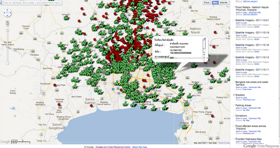
We appreciate the overwhelming response from users in Thailand to help collect and update important information and we continue to invite users to submit new information for layers on the crisis map or send us feedback by clicking the ‘About This Map’ link shown below
เรารู้สึกซาบซึ้งมากกับการตอบสนองของผู้ใช้ในประเทศไทย ที่ช่วยรวบรวมและอัพเดทข้อมูลที่สำคัญ และขอเชิญให้คนที่ต้องการส่งข้อมูลใหม่ๆ หรือแสดงความคิดเห็น คลิกไปที่ “เกี่ยวกับแผนที่” ดังรูป
Flood affected areas
พื้นที่ประสบภัย
Satellite imagery from NASA and radar imagery from Unitar - Unosat indicate the extent of flooding and affected areas across the country.
ภาพถ่ายดาวเทียมจากนาซ่า (NASA) และภาพจากเรดาร์ตรวจอากาศ Unistar-Unosat ระบุตำแหน่งและขอบเขตที่ประสบอุทกภัย
Shelters
ศูนย์อพยพและศูนย์พักพิงสำหรับผู้ประสบอุทกภัย
Daily updates are now available for those seeking emergency accommodation. The green housing icon indicates the location of shelters in and around Bangkok, the capacity the shelter can accommodation and the amount of places still available. Crossed out icons indicate shelters at full capacity.
มีการอัพเดทข้อมูลข่าวสารประจำวันเพื่อเป็นข้อมูลให้กับผู้ที่ต้องการอพยพไปสู่ศูนย์อพยพฉุกเฉิน ไอคอนรูปบ้านสีเขียวจะระบุตำแหน่งของศูนย์ฯ ในเขตกรุงเทพฯ และขีดความสามารถในการรองรับผู้อพยพ นอกจากนั้นยังให้ข้อมูลเกี่ยวกับสถานที่ปลอดภัยที่ยังสามารถโยกย้ายไปได้อีก ส่วนไอคอนที่ไม่สามารถรองรับผู้อพยพได้อีกแล้วจะถูกขีดทับไว้อย่างชัดเจน

Bangkok risk areas and flood barriers
พื้นที่เสี่ยงภัยและแนวคันกั้นน้ำ กรุงเทพฯ
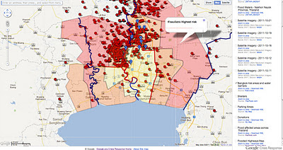
One feature provided by ThaiTV news has received a lot of visitors indicates Bangkok areas at risk of flooding through a red - flooded, orange - high risk and yellow - medium risk colour coded may layer. This feature also shows flood barriers along the Chao Praya River as well as the eastern and western canals being used as diversion routes for water overflow. By using the map zoom in feature, Bangkok residents can identify their street or nearby areas.
อีกฟีเจอร์หนึ่งที่นำเสนอผ่าน ThaiTV ที่มีผู้เข้าชมจำนวนมากเข้าไปแจ้งเกี่ยวกับพื้นที่เสี่ยงน้ำท่วมในกรุงเทพฯ เช่น สีแดง - น้ำท่วมแล้ว สีส้ม - พื้นที่มีความเสี่ยงสูง สีเหลือง - พื้นที่มีความเสี่ยงปานกลาง ซึ่งรหัสสีเหล่านี้มีความแตกต่างกันตามสภาพพื้นที่ ทั้งนี้ฟีเจอร์นี้ยังแสดงแนวกั้นน้ำริมแม่น้ำเจ้าพระยารวมถึงคลองต่างๆ ในฝั่งตะวันออกและตะวันตกของกรุงเทพฯ ที่ใช้เป็นช่องทางเพื่อเบี่ยงการไหลของน้ำ ซึ่งผู้ใช้สามารถซูมเข้า/ออกที่แผนที่เพื่อความชัดเจนและสามารถระบุตำแหน่งถนนที่ตนเองอยู่หรือบริเวณใกล้เคียงอื่นๆ ได้อีกด้วย

Parking
จุดจอดรถในช่วงน้ำท่วม
Users have identified parking spaces for those seeking a safe location for their vehicles. By clicking on the P icon, as shown below, information is provided on the total capacity of car parks and the number of spaces still available as of the date of posting.
การระบุจุดจอดรถในช่วงน้ำท่วมจากผู้ใช้จำนวนมากช่วยให้อีกหลายคนที่ต้องการที่จอดรถที่ปลอดภัย เมื่อคลิกไอค่อน P ดังภาพด่านล่างข้อมูลเกี่ยวกับจำนวนรถรองรับได้ของที่จอดรถแลจำนวนที่จอดรถที่ยังว่างอยู่ ณ วันที่ใส่ข้อมูลนั้นๆ
Donation Centers
จุดรับบริจาคเพื่อผู้ประสบอุทกภัย
If you are looking for a way to help your fellow Thais, donation centers are identified through the shopping bag icons below. By clicking on an icon you can find the name of the donation center, it’s address and where available, a phone number. We advise anyone planning on visiting a donation center to volunteer or drop off goods to call in advance and confirm the center is open during the public holidays.
Photos uploaded from Android phones
ภาพเกี่ยวกับน้ำท่วมที่แชร์ผ่านมือถือระบบ Android
Users, with the help of a special application by Ansur, have recently begun sharing photos taken on Android phones as a new layer to the crisis map. We are working with this user group to share more information for those interested in sharing photos taken from their phones and will provide additional information as soon as it is available.
แอพพลิเคชั่นพิเศษจาก Ansur ทำให้ผู้ใช้แบ่งปันภาพถ่ายจากโทรศัพท์มือถือระบบ Android ที่ระบุตำแหน่งวิกฤตต่างๆ ในแผนที่ ซึ่งเรากำลังทำงานร่วมกับกลุ่มผู้ใช้นี้เพื่อแบ่งปันข้อมูลเพิ่มเติมให้กับผู้ที่สนใจ และจะแจ้งให้ทราบอย่างต่อเนื่องเมื่อมีการอัพเดทใดๆ
As you move the mouse pointer in the 3D viewer, the elevation of the terrain beneath the pointer is displayed in the lower left corner of the 3D viewer. By default, the display of elevation is in feet and miles when high enough.
เมื่อผู้ใช้เลื่อนเมาส์ไปที่มุมมองแบบสามมิติ (3D viewer) ระดับสูงต่ำของสภาพภูมิประเทศในบริเวณนั้นจะแสดงอยู่ตรงมุมด้านล่างซ้ายมือของ “มุมมองแบบสามมิติ” ซึ่งจะแสดงหน่วยเป็นฟุตและไมล์
41 ความคิดเห็น :
Dear Google Thailand,
I am a student studying at the London School of Economics and am interested in conducting a dissertation on last year's Thailand floods. Would it be possible to contact you via email as I am very interested in Google Crisis Response's maps and would like to hear your views on how I could utilise this amazing resource.
Thank you,
Yours,
Dominic
Anda ingin menambah penghasilan? kunjungi situs berikut. website ini lapak303 2019 merupakan situs agen poker online, agen domino online, dan bandar judi terbaik di indonesia link alternatif pokerlounge99 2019 Layanan transaksi kami siap melayani Anda 24 Jam nonstop Produk Permainan berjalan bersamaan dengan promosi yang juujur dan adil serta dengan Staf-staf pendukung kami yang memastikan bahwa dengan bermain di domino qq Anda akan mendapatkan pengalaman bermain Poker Online, Domino Online, dan Bandar judi Online yang terbaik.
Ayo segera Bergabung di dan Jadilah Jutawan bersama kami dengan minimal Deposit hanya 20 rb anda bisa memainkan game ini armani poker
Telah hadir game poker terbaru 2019 terbesar dan terpercaya dengan berbagai macam permainan yang bisa Anda mainkan. Sudah banyak teman-teman Anda yang telah bergabung bersama kami. Untuk itu kami pastikan Anda akan bermain secara Adil pemain VS pemain tidak ada campur tangan robot. Deposit minimal 10K Anda sudah bisa ikut bermain bersama para pemain. Untuk itu kami merekomendasikan beberapa situs poker Terpercaya ini kepada Anda, sudah tidak diragukan lagi. Segera ikuti jejak para pemain-pemain lainya. Anda akan mendapatkan banyak keseruan saat bermain dengan lawan Anda. Sampai tidak sadar bahwa Anda sudah memenangkan permainan tersebut. Untuk itu tunggu apa lagi ? Segera daftar dan dapatkan sensasi yang belum pernah Anda rasakan sebelumnya di situs judi online lainya.
kudapoker
dewaqq
capsa 365
pokerqiu
qiuqiu99
jaguarqq
idrpoker
elangqq
data sgp
data hk
data sydney
paito hk
paito sgp
paito sydney
Sudah kukatakan sebelumnya jika memang situs poker domino online adalah yang terbaik saat ini. Karena banyak sekali kesenangan yang bisa kita dapatkan loh. Begitu juga dengan tips-tips menarik yang pastinya jarang dikasih tau oleh mereka-mereka yang mahir dalam meracik resep-resep terbaik saat ini. Berikut ini adalah beberapa contoh dari resep tersebut:
sahabatpoker
saranapoker
idrpoker
kompasqq
senangpoker
elangqq
pokermas99
wayangpoker
sahabatqq
interqq
Begitulah kata mereka tentang perkembangan di negeri tercinta ini. tapi apa daya jika hanya memberikan komentar daripada solusi. Tetapi kami juga bisa menyediakan beberapa solusi terbaik seperti berikut ini:
kebunpoker
amanqq
lipoqq
maniaqq
redmiqq
wargaqq
rantaiqq
galeriqq
ratucapsa
jasaqq
situs terbaik dengan kemenangan besar
saranaqq
dapatqq
kristalpoker
bonusqq
samudraqq
Situs Pkv games terbaik yang menyediakan permainan bandarq maupun poker qq online dengan bonus turnover terbesar
pusatqq
incarqq
bisaqq
komisiqq
danaqq
wargaqq
janjiqq
akuqq
Armaniqq merupakan situs agen qq online yang memberikan permainan terbaik dominoqq, daftar link alternatif armaniqq gratis.
Situs poker online terpercaya dengan uang asli indonesia
bcaqq
hondaqq
kristalpoker
mainqq
elangqq
Thanks for the information. It's very useful. If any business looking for best web design & PSG Grant eCommerce website developer in Singapore, check our website now for the best web design packages.
website design
web design singapore
SEO Services
SEO Services Singapore
web development company singapore
eCommerce web development singapore
eCommerce website design company Singapore
magento web design company
magento website development
custom web development
I want to thank the author of this article. Because this article is very useful
SahabatQQ
This is sensible information! Where else will if ind out more?? Who runs this joint too? sustain the excellent function DominoQQ
Ceme Online
Slot Online
Secure WiFi (802.1X) support lets organizations protect their wireless network and systems by requiring authentication credentials in order for a Chromebook to connect to the network.
amanqq
suhuqq
nikmatqq
cmcpoker
motorqq
Situs Judi QQ
WarnetQQ
Wahyupoker
TangkasQQ
MakauQQ
CeriaQQ
LapakQQ
ParisQQ
Vipaduq
play and win
sahabatqq
tiketqq
http://202.95.10.210/ adalah agen judi dominoqq, bandarq, sakong, pokerqq online dan pkv games terbaik dengan tingkat kemenangan tertinggi.
Yuk coba ceh pasti asik banget
jaguarqq
rajabandarq
Agen Bola Resmi Ionbet88 Terpercaya Indonesia
Daftar Ionbet88
Situs Ionbet88
Ionbet88
Bola Ionbet88
http://199.188.200.53/sulappq/
daftarpanenpoker
login dunia cash
daftarbromopoker
login panen138
login bromopoker
arahqq
lawanqq
puncakqq
warnetqq
tangkasqq
vipaduq
arenaqq
buktiqq
idmafia
arahqq
Situs Judi QQ Online, BandarQ, Poker Online, Pkv Games Terpercaya
memberpkv.com
Link Alternatif Bwinbet365
Link Alternatif Landakpoker
Link Alternatif Jospoker
Pokerseri Agen IDN Terpercaya
Link Alternatif Untungpoker
Sentapoker Agen Poker Online
Melayupoker Agen IDNPoker Terlengkap
Link Alternatif Bwinbet365
Link Alternatif Landakpoker
Link Alternatif Jospoker
Pokerseri Agen IDN Terpercaya
Link Alternatif Untungpoker
Sentapoker Agen Poker Online
Melayupoker Agen IDNPoker Terlengkap
Link Alternatif Bomjudi
Slot Online Indonesia
Bom Online
Bom Judi
Agen Slot Online Terlengkap
Hobi Spin
Slot Online Indonesia
Hobi Online
Gudang Judi
Gudangjudi
Sentapoker Agen Poker Online
Link Alternatif Cikabet
Kakakslot88 Judi Online Terlengkap
Link Alternatif Bwinbet365
Link Alternatif Landakpoker
Sentapoker Agen Poker Online
Melayupoker Agen IDNPoker Terlengkap
Link Alternatif Cikabet
Hasil ManCity VS PSG
Hobispin
Slot Hobi Spin
Slot Online No 1 Indonesia
Situs Slot Tergacor
Bom Judi
Slot Online No 1 Indonesia
Situs Slot Tergacor
Sentapoker Agen Poker Online
Belanda Bantai Makedonia Utara
Situs Alternatif Mataharibet88
Ciri Situs Slot Terbaik
Info Euro
Info Seputar Betting
Info Dunia Betting
Situs Sportbook Terbesar Indonesia
Sportbook Spesial Euro
Taruhan Bola Euro
Sportbook Spesial Euro
Taruhan Bola
Bomfreespin
Bomjudi
Bom Judi
Bom Free Spin
Situs Slot Tergacor
Slot Gampang Menang
Canlı casino sitenin casino mrbahis olarak oldukça profesyonel bir hizmet sunduğu görülmektedir
Spor firması Malta ve İngiltere monobahis lisanslı olarak yayın yapıyor.
Zira bir gecede üst üste 12 kez modabet karanı geldiği an hala gözümüzün önünde canlanıyor.
Spor üyelik işlemleri için vbet sayfalarımıza göz atarsanız gerekli talimatları alabilirsiniz.
Bir oyun sitesinde atlantisbahis yer alması gereken bir fazlası Spor'te
Spor haberleri bölümünde sahabet resmi site üzerinden derhal erişim sağlamak mümkün olabilir.
Canlı haber sitesi denildiğinde uluslararası privebet alanda akla ilk gelen ofislardan biri belirleme edilen site
Spor kayıt işlemlerini norabahis yapabilmek, son derece hadisedir.
Yapılacak yatırımlar için, vbet yalnızca bir bonustan yararlanma hakkı vardır.
แสดงความคิดเห็น